
Cameron Lake Fire: What Happened, What It Means for Vancouver Island, and How to Stay Safe and Informed
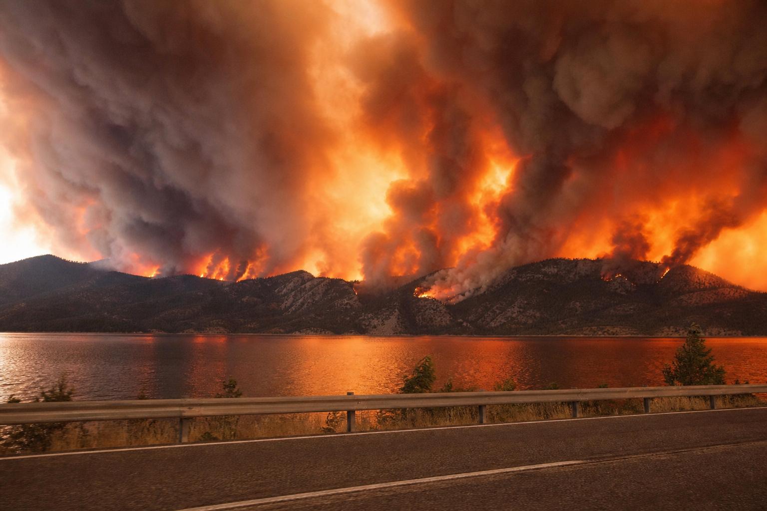
If you live on Vancouver Island, you’ve likely heard someone call it simply “the Cameron Lake fire.” They’re almost certainly talking about the Cameron Bluffs wildfire that burned above Cameron Lake and Cathedral Grove along Highway 4—the lifeline connecting Port Alberni, Tofino, and Ucluelet to the rest of British Columbia. This guide cuts through the noise. You’ll learn what the fire was, why it mattered so much, how to travel safely when Highway 4 is disrupted, what to watch for during wildfire season, and how communities can reduce risk going forward. We’ll also touch on a second Cameron Lake—in Waterton Lakes National Park, Alberta—so you don’t mix up the places or the headlines. By the end, you’ll know where to find reliable updates, what rules apply in British Columbia, and how to make calm, informed decisions when smoke, closures, and uncertainty arrive together.
Why “Cameron Lake fire” Shows Up So Often in Canadian Searches
Canadians search for the term “Cameron Lake fire” for two main reasons. First, the Cameron Bluffs wildfire near Cameron Lake on Vancouver Island triggered weeks of travel disruption. Highway 4 closed and reopened in phases, affecting everything from grocery deliveries to surf lessons. It’s the only paved road in and out of the west coast communities, so even a single downed tree or flare-up can ripple across the entire region. Second, Cameron Lake is also the name of a much-loved spot in Waterton Lakes National Park in Alberta. While the big 2017 Kenow wildfire reshaped Waterton’s landscape, people still use “Cameron Lake fire” when they’re trying to recall past closures to the alpine road and trails there. The overlap in names can be confusing in a search bar, especially if you’re planning a trip.
In other words: same name, different provinces, different fire histories. Most of the time, though, the Canadian news and safety alerts you see about the “Cameron Lake fire” are referring to the Vancouver Island event near Cathedral Grove and MacMillan Provincial Park, close to Qualicum Beach and Port Alberni.
Setting the Scene: Where Is Cameron Lake on Vancouver Island and Why Is It So Critical?
Cameron Lake lies roughly between Parksville/Qualicum Beach and Port Alberni, tucked under steep, forested slopes. Highway 4 hugs its edge for a scenic stretch many of us think of as classic Island driving: big trees, rocky bluffs, glimpses of water through the cedars. That beauty hides a hard truth. The terrain over the highway is steep and unstable, even in a normal year. When a wildfire sweeps through, it can scorch root systems and destabilize entire slopes. After the flames pass, the threat doesn’t. Charred timber can fall months later, especially after windstorms or heavy rain. Rockfall doesn’t care about the calendar either.
This is why a fire in this particular corridor lands differently. It isn’t just a forest event; it’s a transportation and safety event that can isolate the entire west coast of the Island. When Highway 4 shuts down, everything slows: medical appointments, tourism, fuel deliveries, even the mail. Detours rely on gravel industrial roads not built for tourist traffic. Convoys, pilot cars, radio checks, and long wait times become the new normal. The Cameron Bluffs wildfire sharpened that lesson for residents, visitors, and the province alike.
What We Mean by the “Cameron Lake fire” (Cameron Bluffs Wildfire)
The Cameron Bluffs wildfire burned above the lakeshore and Highway 4 near Cathedral Grove. If you saw video of firefighters working on cliffs, helicopters bucketing the bluffs, or crews scaling slopes to remove danger trees, that was likely this incident. The operation was as complex as it looked. Suppression in steep terrain demands caution and patience. Even when visible flames retreat, tree roots can smoulder underground, and crews have to assess which burnt trees might fall towards the road. Hazard mitigation—cutting and lowering trees, prying loose unstable rock, installing netting where necessary—takes time and skilled hands.
As the fire progressed, Highway 4 moved through closure stages: full closure for a period, then restricted convoys, single-lane alternating traffic, and, eventually, more regular openings. Local businesses adapted day by day, posting new hours and delivery windows. Ferries, airports, and service providers updated schedules to match the flow. It was an uncomfortable crash course in how tightly wound the Island’s systems are around that highway—and how quickly a wildfire can tug on every thread.
Impacts You Could Feel in Daily Life
Everyone on the Island knows wildfire smoke can travel. But the Cameron Lake fire was a concrete reminder that even if you aren’t smelling smoke, you might still feel the consequences. Travel times doubled as people queued for convoys or detoured along gravel roads. Households watched grocery supplies fluctuate. Tourism operators juggled cancellations, rebookings, and guests who couldn’t quite tell whether they should come or stay home. A single day’s change in traffic control would ripple into the next morning’s coffee line, fishing charters, and medical rides up-Island.
West coast communities did what they always do: pull together. Volunteer groups delivered essentials to vulnerable neighbours. Local governments and First Nations used every communication channel they had—websites, radio, Facebook groups, road signs—to explain closures and share resources. And many Island residents who weren’t directly affected still lent a hand, offering spare rooms when a trip home wasn’t possible or dropping off masks and air purifiers to friends coping with smoke.
Traveling During and After a Wildfire Near Cameron Lake
Wildfire updates move fast, and the safest choice at 8 a.m. might be wrong by 3 p.m. Here’s a clear way to plan travel around the Cameron Lake corridor during a wildfire, a rockfall response, or any other Highway 4 disruption.
1) Check the official road status right before you leave
In British Columbia, DriveBC is the source of truth for highway closures, convoys, and single-lane traffic announcements. When a wildfire is involved, the page often links directly to maps, schedules, and safety notes. Do a last-minute check on your phone at the trailhead, the hotel, or your driveway. Then check again before you hit the point of no return. It’s not uncommon to see last-hour updates when crews need to close the road for helicopter bucketing or to remove a new hazard tree.
2) Understand detours: what they are and what they aren’t
During the Cameron Bluffs wildfire, the alternate route relied on industrial forest roads. They are not built for daily tourist traffic. Drivers encountered loose gravel, washboard, dust clouds, steep grades, narrow sections with drop-offs, commercial trucks, and long stretches with no cell service. If a detour is active, think like a backroads driver: slow down, carry a spare tire and jack you know how to use, fill your tank before you leave, and bring at least one full day of extra snacks and water. If you’re towing a trailer or driving a low-clearance vehicle, consider waiting for official convoys on Highway 4 rather than risking a long gravel run.
3) Pad your schedule and expectations
A coastal getaway that normally starts with a morning drive might turn into a midday convoy or a dusk arrival. Book accommodation with flexible change policies during peak fire season. If you run a business dependent on drop-off times—deliveries, charters, lessons—communicate early with clients and staff. People are more patient when they know the plan and the reason behind it. Keep your voicemail updated. If you can, automate status posts on your website and social media to confirm what’s open, what’s limited, and how to get help.
4) Know the wildfire rules—because they carry fines and real risks
When the province issues a fire prohibition, it isn’t a suggestion. Under the BC Wildfire Act and associated regulations, officers can fine you for using campfires, fireworks, or sky lanterns during a ban. In general terms, a legal campfire in BC (when fires are allowed) must be small—no bigger than 0.5 metres high by 0.5 metres wide—and you need to keep hand tools and water close by. When a ban is in place, assume the restriction extends to burn barrels, tiki torches, and many types of outdoor wood-fuel stoves, even if they’re in a backyard or on private land. Gas or propane camp stoves typically remain permitted because they have a shut-off valve, but always confirm the exact wording for your fire centre before you light anything. Rules can vary by region and change quickly.
5) Don’t fly drones around wildfire zones
This one’s simple: drones endanger aircraft. If a helicopter or air tanker has to leave a fire line because someone wants a skyline video, suppression slows down and risk to crews increases. Near the Cameron Lake wildfire, steep terrain meant pilots were already working in a complex environment. Keep your drone packed away. If you want photos, shoot from safe, permitted locations and stay behind any traffic control barriers.
6) Bring masks and plan for smoke even if the sky is blue
Smoke doesn’t read maps. Health Canada’s Air Quality Health Index (AQHI) shows you a location-specific risk level that can rise and fall several times a day. If you’re driving towards Port Alberni or the west coast and see haze, or if your weather app mentions wildfire smoke, assume you might step into higher readings by afternoon. Pack a couple of well-fitting respirators (N95 or equivalent) for children and adults in your party, keep car windows closed, set your vehicle to recirculate, and lean on the cabin filter. People with asthma should bring and check their inhalers; anyone with heart or lung conditions may want to shift outdoor activity times to morning or indoor spaces with cleaner air.
How the Cameron Lake Fire Changed Highway 4 Operations
Even though fire season rolls through every year, the Cameron Bluffs wildfire showed the province and contractors where the system needed reinforcement. Steep-slope scaling became a routine part of reopening plans—crews manually removed loose rock and unstable trees that could fall onto Highway 4 weeks later. Traffic control adapted as the risks shifted through the day; sometimes there were short-notice stoppages for helicopter water drops. Portable message signs, social media updates, and radio advisories improved over time, though anyone caught in a long lineup can tell you there’s always room to get clearer, faster, and more consistent.
Longer term, people should expect seasonal caution points through the Cameron Lake corridor. Even without flames, heavy rain or wind after a burn can trigger rockfall and tree failures. A highway that once felt like a quick, pretty link now carries a different weight: it’s beautiful, but it’s also fragile. Travel with that mindset. It helps you absorb minor delays without spinning your plans into panic.
What If You Run a Business in Tofino, Ucluelet, Port Alberni, or Qualicum Beach?
The “Cameron Lake fire” wasn’t just a tourism story. It was a business continuity test. Companies that moved quickest kept customers and cash flow. If you operate a hotel, restaurant, charter, or retail shop in a Highway 4–dependent community, steal these playbook items before the next season:
- Post a standing “Wildfire and Highway 4 Update” page on your site. Keep it evergreen. Update operating hours and the exact steps guests should take to find current road information. Link to official sources.
- Adopt flexible rebooking rules for declared closures and convoy-only days. Put the policy in plain language in your confirmation emails.
- Coordinate with neighbours. A quick WhatsApp or Slack group among downtown businesses reduces duplicated effort and confused messages.
- Train staff to answer the same five questions calmly. Where do I check drive times? What’s the detour like? Should I reschedule? Is there smoke today? Are campfires allowed?
- Keep a small reserve of consumables that run out when trucks slow down: to-go containers, coffee beans, propane, cleaning supplies. Rotate stock to avoid waste.
- Think transportation alternatives. Encourage guests to arrive earlier in the day, or stay an extra night if the highway reopens in the morning. Work with operators on bundled experiences to make a lengthened stay feel like a perk, not a burden.
Community Safety: Evacuation Alerts, Orders, and Your Go-Bag
Language matters during wildfire season. In British Columbia, an Evacuation Alert is a heads-up to get ready to leave on short notice. An Evacuation Order means you must leave now. Agencies share alerts through multiple channels—local government websites, social media, and, when needed, the national Alert Ready system that buzzes your phone. If you live or vacation near Cameron Lake, or anywhere with a one-road access pattern, treat Alerts seriously. The Cameron Bluffs wildfire proved that even without homes burning, the route you depend on can become unsafe very quickly.
Build two kits before you ever need them. The first is a 72-hour go-bag with medications, ID, glasses, a change of clothes, pet supplies, chargers, a small first-aid kit, a headlamp, and snacks. Keep it by the door in a backpack or tote you can grab in the dark. The second kit lives in your vehicle: water, a blanket, maps, a phone charger, a basic tool kit, matches or a lighter (for non–fire ban conditions), and a roadside emergency kit with flares or reflectors. Rotate items at the start of every summer. Label medication bottles with your name and dose, and keep a paper list of doctors and insurers in case you can’t get online.
FireSmart at the Lake: Practical Steps That Matter
Many lake communities in British Columbia sit in the wildland–urban interface, the place where forest meets homes and cabins. If you own or rent a place anywhere near Cameron Lake or similar terrain, spend a weekend on FireSmart basics. Work from the house outwards. Clear gutters. Move firewood at least 10 metres away. Keep decks swept and vents screened. Replace bark mulch beside the house with gravel. Trim branches so none touch the structure, and raise lower branches to reduce ladder fuels. The goal is simple: make it harder for embers to land and ignite something you love.
Municipalities and regional districts often run FireSmart rebates or chipper days, especially after big seasons. Watch for them in the Alberni-Clayoquot Regional District and along the mid-Island corridor. It’s easier to say yes to trimming trees when you’ve got support lined up for disposal and a little help with costs.
Indigenous Fire Stewardship and Prescribed Fire
British Columbia’s fire history did not begin with European settlement, and it won’t end with this decade’s extremes. Indigenous communities across the province have used cultural burning for millennia to manage fuel loads, support food and medicinal plants, and maintain travel corridors. As agencies and communities look for answers after incidents like the Cameron Lake fire, prescribed fire and cultural burning are returning to the toolkit. It’s not a quick fix. It demands planning, collaboration, and respect for local knowledge. But when you look up at a slope that has turned into a chimney, it’s clear that aggressive suppression without thoughtful fuel management leaves us exposed. Prescribed fire can reduce the intensity of future wildfires and protect the very places we value most.
Air Quality, Smoke, and Health: Simple Moves That Help
You don’t need a medical degree to make better choices on smoky days. Check the AQHI for your nearest community. If it’s high, move outdoor exercise to early morning, when smoke sometimes thins, or exercise indoors. If you’re sensitive, consider a portable HEPA filter for one room in your home or rental—create a “clean air room” you can retreat to when the smoke deepens. On the road, keep windows closed, run the fan on recirculate, and change your cabin filter on schedule. If you have asthma or COPD, follow your action plan and talk to your provider before peak season so your prescriptions are current. These small steps can be the difference between a tolerable week and a miserable one.
Safety on the Water and Trails Around Cameron Lake
Cameron Lake is a gorgeous paddle when conditions are calm. In the aftermath of a wildfire, however, hazards multiply. Beware of trees and limbs in the water, especially near shore. Slopes weakened by fire can drop material long after flames are gone. If BC Parks or the province posts area closures around Cathedral Grove or adjacent trails, respect them. A closed sign doesn’t always mean active fire; it might mean hazard tree removal is happening or about to happen. And if a rescue has to be launched into steep ground, it pulls emergency crews away from suppression work they need to do elsewhere.
For hikers, assume uneven footing, ash pockets, and loose rock in burnt areas. A quick step onto a patch that looks firm can turn your ankle or drop you into a hole where roots used to be. Wear sturdy footwear, carry extra water, and let someone know your plan if you head into less-traveled routes. If smoke builds mid-hike, turn around; visibility and orientation go downhill faster than you think when the air turns grey.
Insurance, Bookings, and Cancellations: What Canadians Should Know
Wildfire disruption raises blunt questions about money. Will your hotel refund you if Highway 4 is closed? Do you have coverage if you miss a non-refundable tour? Policies vary, but a few patterns are common in Canada:
- Accommodation providers on the west coast often allow penalty-free changes when DriveBC announces a full closure or convoy-only access. Ask for the policy in writing when you book during summer months.
- Travel insurance may exclude known events. If you buy coverage after a wildfire is already widely reported, some benefits might not apply to trip interruption. Read the specific wording.
- Credit-card trip protection is helpful but limited. If you rely on it, download the certificate of insurance and scan for wildfire and evacuation terms.
- Residents should review home and tenant policies for wildfire deductibles, evacuation expenses, and coverage for food spoilage after a long power outage. If a fridge is lost because of a prolonged closure and resulting outage, some policies will help, some won’t.
How Media, Maps, and Names Collide: Cameron Bluffs vs. Cameron Lake
Here’s a search tip. If your goal is to find current conditions near Cathedral Grove, try adding “Cameron Bluffs wildfire” or “Highway 4 closure” to your search. If you want the Alberta lake, use “Cameron Lake Waterton” or “Cameron Lake road Waterton.” News outlets and government pages sometimes shorten names to fit headlines, which is how “Cameron Lake fire” became the default phrase people trade in conversation. Being precise saves you from reading the wrong province’s rules or calling the wrong park office.
What About Waterton’s Cameron Lake in Alberta?
Waterton Lakes National Park is home to a high-elevation Cameron Lake at the end of a scenic road. The 2017 Kenow wildfire reshaped the park dramatically, with closures that affected the Cameron Lake area for a period after the main event. Parks Canada continues to manage trails, facilities, and ecology recovery with an eye to both visitor safety and long-term forest health. If you’re heading there, check Parks Canada advisories for Waterton, especially in late summer when the fire danger rises across southern Alberta. Like the Island’s Cameron Lake, it’s a gorgeous place ringed by steep slopes. And the same basics apply: check conditions, be flexible, and follow posted restrictions strictly.
Why Slope and Soil Matter After a Fire
Fire doesn’t end when the last visible flame goes out. It can shock the soil, especially on steep ground like the Cameron Bluffs. Hydrophobic layers sometimes form after intense heat, causing rain to run off instead of soaking in. That means flashier runoff, higher debris flow risk, and—yes—more rockfall and slides that can affect Highway 4. Vegetation will come back, but not instantly. In the meantime, agencies use a mix of tools to lower risk: hazard tree felling, rock scaling, fencing, targeted closures, and careful monitoring after storms.
For drivers and cyclists, it means treating post-fire corridors with caution for at least a full season, often longer. If a heavy rainstorm is forecast, expect short-notice closures. If the wind picks up, watch for traffic-control points to tighten operations until gusts ease. This isn’t overreaction—it’s evidence-based risk management rooted in lessons from past incidents.
How Fire Behaviour Gets Fierce in the Cameron Lake Corridor
When you picture trees above a highway, imagine a tilted chimney. Slopes funnel wind. Canyons and lakes channel breezes that can turn an ember into a fast upslope run. Near Cameron Lake, the alignment of the bluffs, the forest type, and the exposure can align for sudden intensity. That’s why you sometimes see dramatic helicopter and ground operations in footage from the site. When topography, dryness, and wind work together, fires produce spot fires that jump ahead. Crews then have to chase, flank, and box those spots before they connect and turn into a front. It’s highly technical work, and it happens in a place you’ve probably driven with a coffee in hand without a second thought.
Staying Informed: The Sources That Count in BC
Sifting through social media during a wildfire can feel like drinking from a firehose. Stick with official channels first, then layer on trusted local voices. For the Cameron Lake and Highway 4 corridor, here’s a reliable stack to check in order:
- DriveBC: Real-time closures, convoys, single-lane information, and incident notes for Highway 4.
- BC Wildfire Service: Fire status, size estimates, danger ratings, prohibitions, and interactive maps via the website or app.
- EmergencyInfoBC and local government pages: Provincial-level alerts and links to regional and First Nations updates, including evacuation alerts and orders.
- BC Parks and park-specific pages: Area closures for Cathedral Grove (MacMillan Provincial Park) and nearby parks or trail systems.
- Regional District and municipality channels: Alberni-Clayoquot Regional District, City of Port Alberni, Town of Qualicum Beach, and Indigenous governments in the region share localized instructions and services.
- Local radio and community pages: Helpful for context, interviews, and community needs.
Cross-check at least two of these before you decide. If someone’s Facebook post says “It’s all clear,” but DriveBC shows a full closure, believe DriveBC.
Practical Packing and Vehicle Prep for the Highway 4 Corridor
You don’t need to overland like you’re crossing the Sahara, but a little forethought helps you arrive in better shape if closures or smoke complicate things. Consider this short list before you head towards Cameron Lake and the west coast during fire season:
- Fuel: Top up in Parksville, Qualicum Beach, or Port Alberni.
- Water and food: Enough for at least 24 hours beyond your plan.
- Masks: A couple of N95s or similar respirators for each person.
- Navigation: Download offline maps; cell service can be spotty around the bluffs.
- Light and visibility: Headlamp and a high-visibility vest if you end up walking near traffic control at night.
- Cash: Some small businesses lose connectivity during disruptions.
- Tires: Check pressure and tread; gravel detours are tough on rubber.
- Patience kit: A book, playlist, games for kids. You might wait.
Worksites, Contractors, and Safety Compliance Near Fire Zones
If you’re a contractor working anywhere near Highway 4 or the Cameron Lake corridor during or after a wildfire, build wildfire compliance into your job setup. Follow provincial restrictions on open flame and hot works. Some areas will require spark arrestors on equipment and tight watch schedules when welding, grinding, or doing anything that can throw sparks. Maintain a fire watch after hot work ends, keep extinguishers handy, and stage water and hand tools within reach. Your crew’s choices can keep a small incident small—or create a new one that sets everyone back weeks.
Tourism Messaging That Works During a “Cameron Lake fire” Event
If you’re on the communications side—tourism board, chamber, destination marketing—your tone matters. Aim for calm, factual, and current. Tell visitors plainly whether travel is possible and what it will feel like. “Highway 4 is open to single-lane alternating traffic with up to 30-minute delays. Please bring water, fuel up, and expect to queue at this kilometre marker.” Then show what’s open and safe to enjoy. Don’t oversell blue skies if the AQHI is high. Visitors can handle truth when it’s paired with clear options.
After the Smoke: Recovery, Reopening, and Watching the Weather
Communities take a deep breath when a wildfire is declared “held” or “under control,” but the recovery period still needs attention. On steep corridors like Cameron Bluffs, hazard mitigation becomes routine maintenance. Work crews return for scaling runs after windstorms. Park managers reopen sections in stages as trees and slopes are made safe. Businesses may take a week or two to restock fully after long detours. If you return to hike Cathedral Grove after a closure, expect to see signage explaining what changed, where to stay on the trail, and what areas remain out of bounds. Respect those lines; they exist to protect you and the restoration work under way.
Climate Signals and the New Normal on Vancouver Island
British Columbia has always had fire, but the pattern is shifting. Longer dry spells and higher temperatures prime forests for faster spread and more intense behaviour. That doesn’t mean every year will look like the worst year you remember. It does mean communities around narrow mountain corridors—like the Highway 4 stretch by Cameron Lake—should treat wildfire and post-fire hazard as part of their annual planning. Households can get FireSmart. Businesses can harden supply lines and policies. Governments can invest in slope stabilization, prescribed fire, and clear communication systems. None of these steps makes wildfire vanish. Together, they keep small incidents from turning into regional emergencies.
Respect on the Road: Sharing Space With Crews
When you drive through an active work zone by Cameron Lake, you’re rolling through someone’s office. That office might hang off a rope on a cliff or sit in a bucket seat under a rotor. Slow down, follow pilot cars, and put the phone away. If a flagger asks you to wait, say thanks. They’re holding the line between you and a falling tree. If you stop in a lineup, leave a gap for emergency vehicles to thread through. When the road reopens fully, remember who made it possible: the people who spent weeks checking every tree you now whip past in fifteen minutes.
Local Examples: How Island Communities Adapted
During the Cameron Bluffs wildfire, Port Alberni businesses staggered delivery windows so trucks could make the most of convoy times. West coast hotels automated emails to guests with the day’s Highway 4 status, maps of queueing points, and suggested arrival windows to avoid peak hold-ups. Surf schools offered flexible reschedules and shared guides on how to drive the detour safely if visitors chose that route. Municipalities posted clear, no-nonsense breakdowns of campfire bans, including what was and wasn’t allowed under provincial prohibitions. These simple moves didn’t just keep visitors informed; they kept tempers low and community ties high.
How to Talk to Kids About Wildfires and Closures
Wildfires are frightening. If you’re traveling as a family during a Highway 4 closure, keep explanations simple and empowering. “There’s a fire up on the mountain. Firefighters are working hard to make the road safe, so we need to wait our turn.” Give kids a job—snack monitor, traffic-counting champion, playlist DJ. Share what you’re doing to stay safe: checking official apps, keeping water in the car, wearing a mask if it gets smoky. When they feel part of the plan, they feel less afraid.
For Photographers and Sightseers: Do’s and Don’ts
Many of us are drawn to big landscapes and bigger events. But there’s a right way to witness a wildfire’s aftermath:
- Do shoot from legal pullouts and safe distances. Don’t stop in live lanes or on blind corners along Highway 4.
- Do obey closure signs near Cameron Lake, Cathedral Grove, and adjacent trails. Don’t duck a barrier for a “quick shot.”
- Do credit and share official information. Don’t post speculative rumours about evacuation orders or road closures.
- Do consider the people who live there. Big fires are not backdrops; they’re lived experiences for your hosts.
Frequently Mixed-Up Terms and Places
Quick refresher to cut confusion when you’re scanning updates:
- Cameron Lake, Vancouver Island: Along Highway 4 near Cathedral Grove (MacMillan Provincial Park), between Qualicum Beach and Port Alberni. The Cameron Bluffs wildfire burned above this area, causing Highway 4 closures.
- Cameron Lake, Waterton (Alberta): High-elevation lake at the end of a scenic road in Waterton Lakes National Park. The 2017 Kenow wildfire heavily impacted the park, with subsequent closures and restorations over several seasons.
- Highway 4: The only paved road to Tofino, Ucluelet, and the Pacific Rim portion of Vancouver Island’s west coast. Susceptible to closures when the Cameron Lake corridor is unsafe.
- Cathedral Grove/MacMillan Provincial Park: Beloved stand of old-growth trees near Cameron Lake; area closures may occur during wildfire or post-wildfire hazard mitigation.
What to Do If You Live Year-Round Along the Corridor
Residents face a different calculus than visitors. Build redundancy into your life during wildfire season. Keep two weeks of essential medications on hand if possible. Stash a small stock of pantry items you know you’ll eat. Arrange carpooling for medical appointments in Nanaimo or Victoria so you can flex to convoy times. Back up work files locally if your connection becomes unreliable. Print out a contact sheet with phone numbers you’d normally pull from your device. And consider joining or forming a neighbourhood preparedness group—nothing beats a quick text chain to coordinate rides, runs, and check-ins for elders when the road is limited.
When Headlines Say “Cameron Lake Fire Today”
Search spikes happen when something changes quickly: a new closure, a visible flare-up, or a rumour that needs checking. If you see “Cameron Lake fire today” in your feed, go straight to DriveBC and the BC Wildfire Service map or app. If there’s a real change, you’ll see it there. Then adjust. If nothing official has shifted, resist the urge to amplify unverified posts. Well-meaning shares can clog channels and increase stress for everyone watching the same handful of kilometres of asphalt and bluffs.
Preparedness Table: Your Quick-Check Before a Highway 4 Trip
| Item | Why It Matters | Done? |
|---|---|---|
| Check DriveBC within 30 minutes of departure | Convoys and closures can change hour by hour | |
| Confirm BC Wildfire Service status | See fire location, prohibitions, and danger ratings | |
| Fuel up in Parksville/Qualicum or Port Alberni | Prevents stress if traffic control adds delays | |
| Pack water, snacks, masks | Queues and smoke can appear unexpectedly | |
| Download offline maps | Cell service can be patchy near the bluffs | |
| Check campfire rules for your fire centre | Prohibitions change; fines apply |
Looking Ahead: Lessons From the Cameron Lake Fire
The Cameron Bluffs wildfire will not be the last test for Highway 4. But it’s already taught us a set of lessons that travel well across British Columbia:
- Critical corridors need fire-aware maintenance plans. Slope and tree hazards require steady attention long after the last hose is rolled.
- Communications should be layered and consistent. DriveBC first, then local governments, then tourism operators echoing the same facts.
- Flexibility beats certainty in bookings and operations. When everyone builds some slack into schedules, fewer trips fall apart.
- FireSmart work at the property level reduces risk where suppression is hardest—on steep, roadside slopes.
- Indigenous fire stewardship and prescribed burns can lower the odds of catastrophic runs in the very places we can least afford them.
If we live with those lessons, the next “Cameron Lake fire” headline lands softer. Not because the event is smaller, but because we are better at moving with it.
FAQs: Cameron Lake Fire, Highway 4, and Wildfire Travel in BC
Is “Cameron Lake fire” the same as the Cameron Bluffs wildfire?
Most people using “Cameron Lake fire” are referring to the Cameron Bluffs wildfire on Vancouver Island, which burned above Cameron Lake and Cathedral Grove and impacted Highway 4. It’s the same incident area; the formal name used by agencies was Cameron Bluffs.
Is Highway 4 open right now?
Conditions change. Check DriveBC for the current status of Highway 4 before you travel. It will list closures, convoys, single-lane alternating traffic, and estimated delay times when available.
Can I drive the detour if Highway 4 is closed?
Detours, when active, often use gravel industrial roads not designed for heavy public traffic. Expect rough surfaces, dust, limited services, and low or no cell coverage. If you’re not comfortable with backroads driving, it’s usually safer to wait for official convoys or planned openings on Highway 4.
Are campfires allowed near Cameron Lake?
It depends on current prohibitions. Under BC’s system, campfires may be banned during high hazard periods. When allowed, a campfire must be small (no more than 0.5 m by 0.5 m), attended at all times, and fully extinguished before you leave. Always check the specific fire centre’s prohibition list the day you plan to light a fire.
Why does the highway stay restricted even after the flames are out?
Burnt trees and loosened rock can fall for weeks or months after a fire, especially on steep slopes like the Cameron Bluffs. Crews need time to remove hazards and stabilize slopes. Traffic control protects drivers and workers while that happens.
What should I pack if I have to travel during a wildfire near Cameron Lake?
Fuel up, bring at least a day’s worth of extra water and snacks, carry masks for smoke, download offline maps, and keep chargers handy. Patience matters too—expect queues and be ready for last-minute changes to traffic control.
Can I fly a drone to get footage of the Cameron Lake wildfire area?
No. Drones are prohibited around wildfire operations. They endanger aircraft and can halt suppression work. Even after a fire is controlled, obey any posted no-drone zones and temporary flight restrictions.
What’s the difference between an Evacuation Alert and an Evacuation Order in BC?
An Evacuation Alert means be ready to leave quickly; pack essential items and prepare your home. An Evacuation Order means leave immediately. Follow directions from local authorities and do not return until officials say it’s safe.
Is the Cameron Lake in Alberta affected by the same fire?
No. Cameron Lake in Waterton Lakes National Park is a different location in a different province. While Waterton experienced significant wildfire impacts in 2017 (Kenow fire), the “Cameron Lake fire” most Canadians mention in recent years refers to the Vancouver Island incident near Cathedral Grove.
How can businesses reduce cancellations during Highway 4 disruptions?
Post a clear status page, offer flexible rebooking, send automated update emails to guests, and coordinate with neighbouring businesses for consistent messaging. Clear information and options keep most customers on your side.
Where do I find accurate wildfire maps for the Cameron Lake area?
Use the BC Wildfire Service’s official map or app for current wildfire locations, status, and prohibitions. Pair that with DriveBC for road conditions. Local government pages and EmergencyInfoBC provide evacuation and alert details.
Do FireSmart steps really help if the fire is in steep terrain?
Yes. While no approach guarantees protection, FireSmart actions reduce ember ignition risk and improve the odds that suppression crews can defend structures. In tight corridors like Cameron Bluffs, every reduced fuel source counts.
What should I do if smoke triggers my asthma while I’m traveling?
Follow your asthma action plan, use your reliever inhaler as prescribed, and move to cleaner air—inside a vehicle with recirculate on or indoors with a HEPA filter. Consider delaying strenuous activity and consult a medical professional if symptoms escalate.
Will Highway 4 keep facing closures in future summers?
It’s possible. Steep terrain plus post-fire conditions mean closures and traffic controls may recur during high wind, heavy rain, or hazard mitigation work. Plan with flexibility each summer and monitor official channels closely.
How can I support communities affected by the Cameron Lake fire?
When travel is safe, visit. Book local. Tip generously. If closures return, consider buying gift cards, ordering from businesses online, or donating to reputable local aid organizations serving residents and First Nations in the area.